[contact]

[legal & copyright]


Available Video Footage
 Trollstigen1 Jul 2018
YouTube: adRsfMwpnQk★★☆☆☆
 Queen Valley (AZ)5 Apr 2018
YouTube: 4KeZ7Pzbd9U★★★★
 Suchá14 Oct 2017
YouTube: lnIUh2bPxu0★★★★★
 Crucea de Piatră3 Oct 2017
YouTube: P-iFx3VIiQ0★★★★★
 Crucea de Piatră14 Sep 2017
YouTube: mWvP3QG18v0★★★★
 Fort St. John (BC)3 Sep 2017
YouTube: d3ajks8OHCo★★★★★
 Weert25 May 2017
YouTube: h0s_P74oQD4★★★★
 Port Tabacco (MD)18 Mar 2017
YouTube: 2wII24qSpDw★★★★
 Volgograd (VGG)18 Mar 2017
YouTube: _p_inSwZcPQ★★★☆☆
 Charles Town (WV)Feb 2017
YouTube: JJpSYozvasc★★★★
 RugeleySummer 2016
YouTube: mgrI0MHZQQc★★★☆☆
 New York City (NY)Jul 2016
YouTube: QGKkhZE2Fk0★★☆☆☆
 Ayden (NC)16 Oct 2016
YouTube: 6BUA6zdbgEE★★★★
 Nueva Talcuna24 Mar 2016
YouTube: O9R1wMq0VOI★★☆☆☆
 Maryland Point (MD)12 Dec 2015
YouTube: 9P2A8m7RgnA★★★★★
 Sion13 Nov 2015
YouTube: dNrtU1z_5EQ★★★☆☆
 Westbury26 Sep 2015
YouTube: VjW_QyXtyHA★★★★★

 Kavrov (VLA), 3 Jun 2017


 Abstract  The object approaches the camera in a steep angle from the ground towards the high flying drone above it. The speed cannot be estimated precisely by referring to covered ground. However, the common blurred line that the object leaves in more than only the last single frame indicates a supersonic speed comparable to the other cases of supersonic objects that pass the drones closely.


Video Info
Source:YouTube.com/watch?v=9QZvy_SJT8E
User:Александр Угрюмов 
Published:05 Jun 2017
Resolution:1080p
Frame rate:30fps
Drone model: unknown
Files: archived original description and comments on YouTube
Content Info
Viewpoint*: 56.306335, 41.392393goo.gl/maps/a9F4fMVkwDM2
Time: 03 Jun 2017 13:30 (Moscow Time, UTC+03:00)
Weather: 9-10°C, 1005hPa, 45-64% humid., 14.4-21.6 km/h wind Smore 
Object Analysis Results
Appears in frames:240 to 252 (00:08:0 to 00:08:400 m:s:ms)
Object's direction:NW to SE
Data insufficient to estimate passed distance and traveling speed
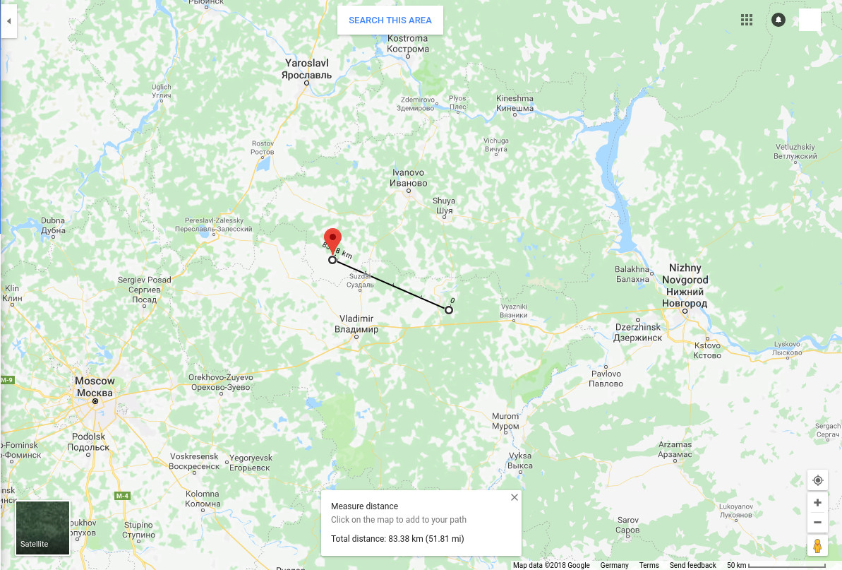

Fig A.1. Distance between camera and nearest publicly available weather station at Bekserevo Air Station.


* Geographic coordinates are given as a vector of latitudes and longitudes in format WGS 84 as used by Google maps.

† The detailed point in time of the capture was stated by the originator of the footage.


Contact Donate Legal & Copyrights Author

© whitefastmovers.org 2018-2024